My partners and I loading the plane
My partners and I loading the plane


if Alaska is the last frontier, then Gates of the Arctic is the true test for the modern pioneer. Located entirely north of the Arctic Circle, Gates of the Arctic is four times the size of Yellowstone National Park. There are no roads into or inside the park, no established trails, no designated campgrounds. it is the least visited national park in the US with an average of 5,000 to 8,000 visitors per year. Most landmarks on topographic maps don’t have names. The park and preserve are located within the Central Brooks Range which is the highest northernmost mountain range in the world.
Gates of the Arctic is the home of grizzly bears, polar bears, black bears, wolves, moose and large herds of caribous.
The terrain features a network of wild rivers, acting as “natural highways” throughout the park. Pack-rafting is the fasted means of travel and many explorers will mix pack rafting and backpacking, oftentimes carrying their packrafts across valleys and mountain passes.
Rivers are bordered by large mountains, featuring pristine glaciers, lakes and alpine valleys. The thick and humid boreal forrest, covers a large swath of the mountains. The foothills are dominated by the arctic tundra, a deceiving and difficult terrain which will challenge the most avid adventurers.
Being one of the most remote and wild region on the planet, Gates of the Arctic is not for the faint of heart. During the Summer, which lasts from June to August, temperatures will vary between 60F and 15F. Rain is also a daily occurence and the the sun never sets, providing for nearly 24h of daylight. Winter is an entirely different beast with temperatures ranging from -65F to 0F. The sun almost never rises. Fall is brief and provides vibrant and beautiful colors. Spring (February to April) is usually the best time for a snow adventure (on snowshoes, skis or dog sled).
Aurora Borealis are usually visible between September and May. June and July are characterized by swarms of mosquitoes. Rivers and lakes usually freeze by September and will remain solid until the end of May.
I recommend venturing in Gates of the Arctic in groups of 3 to 5. A small group is the best deterrent agains both predators and any unforeseen incident. All group members must be experienced outdoor enthusiasts. Skills in navigation, route marking, off trail travel, risk assessment and bear deterrence are mandatory.
While Gates of the Arctic is not for everyone, it is the adventure of a lifetime. Alaska is reminiscent of what the West once was: a virgin land, denied of agricultural and industrial scars, where nature’s reign is claimed high and loud over all things. If you feel you have what it takes to explore America’s true last wild frontier, look no further than Gates of the Arctic.
Courtesy of National Park Service
To access the park, you first need to fly or drive to Fairbanks, AK, about 400 miles south of the park. From there, depending on the season and your objectives, you will rely on small propeller planes. Note that the only “road” north of Fairbanks is the Dalton Highway, a remote gravel road built along the pipeline that runs from Prudhoe Bay.
Most visitors access the park via bush plane. Several private services are offered via the few airfields surrounding the park.
There are there main airfields to access the park.
Bettles, AK
Bettles, a small town 250 miles north of Fairbanks, featuring a saloon, a few log homes and a gravel runway. There are no road access to Bettles, AK expect for an ice trail in the winter which can be accessed by driving up the Dalton Highway. To access Bettles the rest of the year, you will need to book a 1h flight through Wright Air Services out of Fairbanks.
Brooks Range Aviation is the main air taxi service out of Bettles airfield. It is own and operated by Jay and Judy Jepersen.
Keep in mind that most car rental companies in Alaska specifically prohibits driving their vehicles on the Dalton Highway, so if your goal is Gates of the Arctic, I recommend flying.
2. Coldfoot, AK
Coldfoot, AK can be reached by driving the Dalton Highway or flying with Air Wright. Services
Fly Coyote is owned by pilots Dirk Nickisch and Danielle Tirrell and is the main air taxi service operating out of Coldfoot.
3. Anaktuvuk Pass, AK
The Native American village of Anaktuvuk Pass is located at the far north-east edge of the park. Wright Air Services operates direct flights from Fairbanks, AK.
Other smaller companies besides those listed may provide flights to Gates of the Arctic. I encourage you to book your flights several months in advance and to prepare to be flexible as the fleet of bush planes are limited. Be prepared for last minutes changes as adverse weather conditions may ground the planes and alter your trip.
Bush planes flying into Gates of the Arctic will land on sandbars, lakes or large river forks. You will need to coordinate with your pilot the exact locations of drop offs and pick ups as well as alternative locations should your trip be altered.
During the summer, the tundra and boreal forrest get invaded with hordes of mosquitoes. We’ve all heard of mosquitoes in the rockies or in the Sierra, especially in the summer when the snow melt and stillwater ponds are formed. Alaska is no stranger to this phenomena, however the mosquitoes you will meet in the last frontier are an entirely different breed of fighters. They will attack relentlessly any living thing oftentimes stinging through layers of fabric. While none of the mosquito species present in Gates of the Arctic are known to carry any diseases, preparation is still paramount. I recommend that you treat your clothing and fabric with Permethrin insect repellent prior to departing and that you apply deet on exposed skin at least twice a day. I also recommend that you wear pants tucked inside your socks with gaiters, long sleeve shirts and well as a head net. Don’t forget to keep your tent closed at all times. If those guidelines are respected, you can expect between 40 and 60 mosquitoe bites on your body at any given time. If those guidelines are ignored, the outcome will likely be in the hundreds. Rest assured, 40-60 bites is actually more manageable that you may think and your body will quickly adjust.
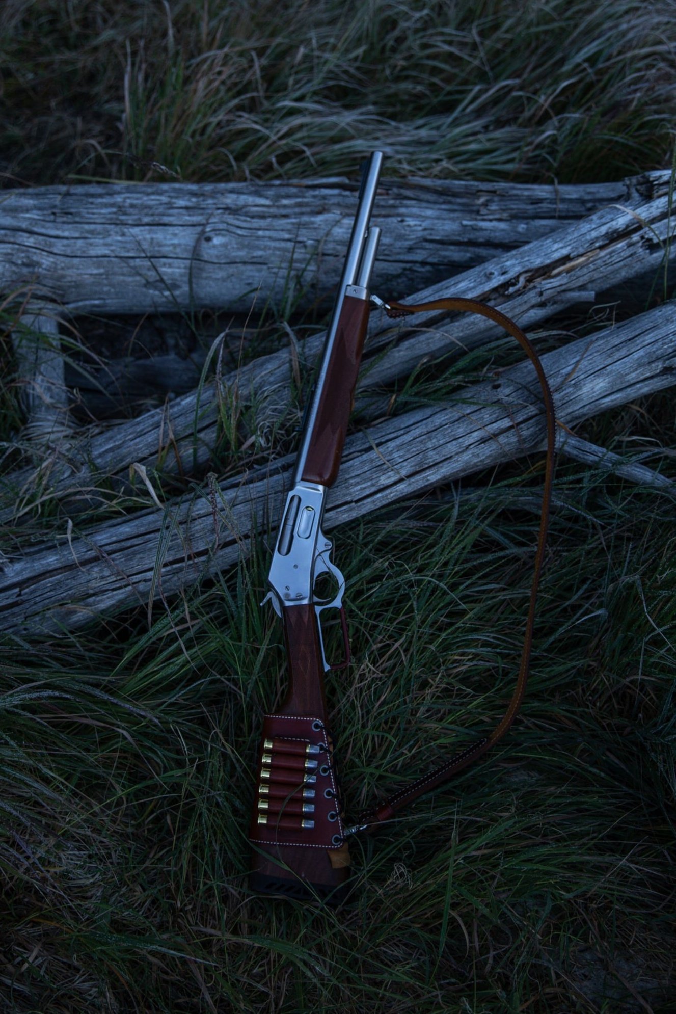
My Marlin Guide gun chambered in 45/70
The majority of people venturing into Gates of the Arctic carry firearms. Not only is it effective against predators, it can also be used for survival in the event that your trip does not go as planned. When venturing hundreds of miles from the nearest point of civilization, one will need to consider extreme scenarios: A bad weather event could ground your plane for several days, leaving you to fend for yourself in this giant wilderness. A lost or damaged satellite radio could cut all communications with your pilot. An injury could keep you stranded on a wooded mountain slope, making it difficult for search and rescue to locate and reach you. While the members of your party must be proficient at disaster management, a firearm is oftentimes a necessity.
Not all firearms are however created equal. Your typical 9mm, 45ACP or 556 round, while efficient in military and urban environments will be useless against some of the world’s largest predators. You will need to consider large game calibers. I personally favor a Marlin Guide Gun chambered in 45/70. I find it to be an extremely well made, rugged, relatively easy to carry and accurate rifle. When opting for a revolver, I recommend that you look at the Ruger Super Alaskan 454 casull or if you want to be fancy, the Freedom Arms Model 83. Always use hard cast bullets as these will prove efficient against large game.
As always, a firearm is only as efficient as its shooter. Learning how to use those firearms in a situation of stress is essential. I highly recommend training with those calibers and getting comfortable with them. Keep in mind that when faced with a charging bear, you will get at best two shots. Make sure those shots are accurate. If hunting becomes a necessity for survival, those calibers will serve you well.
Finally, while this might seem obvious to most readers, I feel compelled to remind each and every one of you that a firearm should be safely holstered on your belt or chest and readily available. A revolver tucked inside a backpack is not going to be of any use.
Bear spray should also be carried by at least one member of your party. Your party should also have a plan of action in the event that something goes wrong. I usually instruct my partners to form a horizontal line to ensure no one is behind.
All other means of bear deterrence (such as using a bear canister or hanging your food) should be observed.
Pro tip: One of the only recorded fatalities in the park was a woman who got mauled by a grizzly while undergoing some private business. Alway carry your means of defense when relieving yourself in the woods.
Carrying a satellite beacon is essential regardless of the adventure you undertake. It allows to contact and communicate with search and rescue in the event of an emergency. When venturing in Alaska, a satellite phone is also necessary. A satellite phone will allow better coordination with your pilot and provide a second mean of communication should the beacon fail. I recommend the Iridium Extreme 9575. Make sure to bring a spare battery.
I assume that anyone reading this report will be familiar with the traditional layering system used in outdoor pursuits, therefore I will not go into the details of which clothes to bring. However I recommend bringing gaiters in the summer. Remember that when bushwhacking through the tundra and boreal forrest, the ground will be in a permanent state of humidity. The Tundra is essentially a giant wet sponge where rain is a daily occurence. Your pants and shoes will be soaking wet all day. A pair of gaiters will not only keep your ankles dry but will also prevent your feet from getting wet. Make sure to wear a pair of solid goretex boots to keep your feet dry and ankles secure when walking over tussocks fields.
In this report, you will find two maps:
The first map is my personal map from this specific trip, shown below.
The second map is a generalized map with a variety of landmarks and routes in Gates of the Arctic
We wake up at the break of dawn in Bettles, AK. Today’s objective is to fly to Circle Lake as soon as a weather window opens. Impatiently awaiting for our pilot’s green light, we sip our last cup of coffee and double check our gear on the tarmac. Finally, we get the go ahead. Our pilot immediately drives us to a small lake where a fleet of hydroplanes is parked. Our plane is a Beaver, the classic arctic workhorse. Though our beaver is a plane manufactured around 1950, it still looks almighty. Our pilot helps us haul our gear onto the back of the plane. Our gear include 3 large backpacks, 8 days worth of food and an inflatable raft & paddles. The plane has barely enough cargo space to fit everything. Flight checklist done, we are at last taking off from Bettles Airfield, heading towards one of the most remote wilderness in the Northern hemisphere. As we head into the clouds, we glance at the Koyukuk river, which flows nearby Bettles, AK. We fly over the Alaskan tundra, which consists mostly of flat green swamps, tussocks fields interlaced with a multitude of rivers and creeks. At last, we see mountains. We are heading toward the Brooks Range!
50-min after taking off, our pilot points our objective in view: Circle Lake. Circle Lake is a popular spot for pick ups and drop offs in the park. Circle lake forms an L-shape, it is narrow and deep making it a perfect spot for landing. As we fly around the lake, positioning our plane for landing, our pilot points out the few drainages that connect the lake to the Alatna River. Most pack rafters will usually portage their gear from the landing spot onto the river. This portage can be a brutal undertaking over the difficult Tundra terrain. Being able to navigate the drainages can drastically reduce the time it take to connect the lake to the river. This information from our pilot will turn out crucial in the next few days.
As our plane makes its approach, a flock of wild ducks suddenly fly away, our first encounter with an ever abundant wildlife few places on the planet can claim .
The first part of our expedition consists in exploring the Arrigetch mountains by going up Arrigetch Creek. We pack for a 4-day trip and stash the rest of our gear nearby Circle Lake.
We start our day by hiking 2.5 miles through the tundra to join Arrigetch Creek. The milage for our trip isn’t significant, especially when comparing to hikes in the lower 48. However, one should bear in mind that hiking off-trail is considerably more time and energy-consuming than hiking on a trail that is already blazed. Hiking off-trail in the Alaskan bush adds another layer of difficulty. I had watched several videos and read plenty material on what hiking through the Tundra is like, yet I only truly understood its challenge once I was there in person. The best way to describe the Tundra is to think of a giant wet sponge, interlaced with unstable grassy outgrowth called tussocks. Tussocks are what make the Tundra one of the most difficult terrain. You can either step on tussocks or walk between them. Stepping on a tussock runs the risk of losing your balance or in the worse case, twisting an ankle. Slipping between them sinks you deeper into the ground. The giant sponge makes each step unstable and energy-consuming. It’s essential to understand that the tundra consists primarily of permafrost. The arctic tundra is stark and treeless. Roots can’t penetrate the frozen soil, so only moss, lichen, and low shrubs can grow there. In summer, the topmost layer of the permafrost melts, leaving behind soggy ground, marshes, bogs, and lakes, often infested with mosquitoes.
After negotiating our way through the tundra for roughly two hours, we finally reach Arrigetch Creek. Arrigetch Creek is a gorgeous river which takes its source in the Arrigetch mountains, roars down through canyons and dumps into the Alatna River. The river is surrounded by spruce trees, forming a portion of the boreal forrest. From there we head west up towards the mountains by following the creek. The terrain is slightly easier than the unforgiving tundra’s tussocks fields and only becomes easier with elevation. Walking through the Boreal forrest is a unique experience, reminiscent of the rainforest of Southeast Asia. While the tundra consists mainly of an arctic desert with no landmarks, the boreal forrest is lush, green, wet and dense, tho providing limited visibility. One must pay attention when walking through the boreal forrest as a surprised encounter with a grizzly bear or a bull moose is more likely than anywhere else.
For the first few miles up the Arrigetch Creek, the river roars through a steep canyon with little to no camping spots. However, after bushwhacking roughly 3 miles and climbing 1,000 ft, we find ourselves faced with a beautiful sight: The creek suddenly splits into two forks and forms an island of mostly flat parcels, providing for a perfect camping spot. On one end of the island, the river flows freely, on the other end, a series of rock formation form a deep pool of still water, fed by a steady flow. We set up camp, had a refreshing bath in the nearly freezing water and called it a night.
My partners and I loading the plane
We wake up to a light rain. Thing morning, we deice to take our time and get a late start. One of the perks of venturing in the arctic during the summer is the nearly 24-h daylight. Time becomes irrelevant. It is an exulting feeling and a stark contrast from the rat race we all experience in what we call the “civilized world”.
Today’s objective is to reach the Aquarius Valley, an alpine valley nestled in the Arrigetch mountains. As we gain altitude, the creek become shallower and spruce trees, once tall and dense suddenly become scarce, leaving way to the wide open view of the distant peaks. The terrain become much more solid and dry. This area is reminiscent of the Eastern Sierra. The air is cooler, dryer and mosquitoes are now a fading memory. After hiking roughly 3 miles, we head south following a small creek, up the Aquarius Valley.
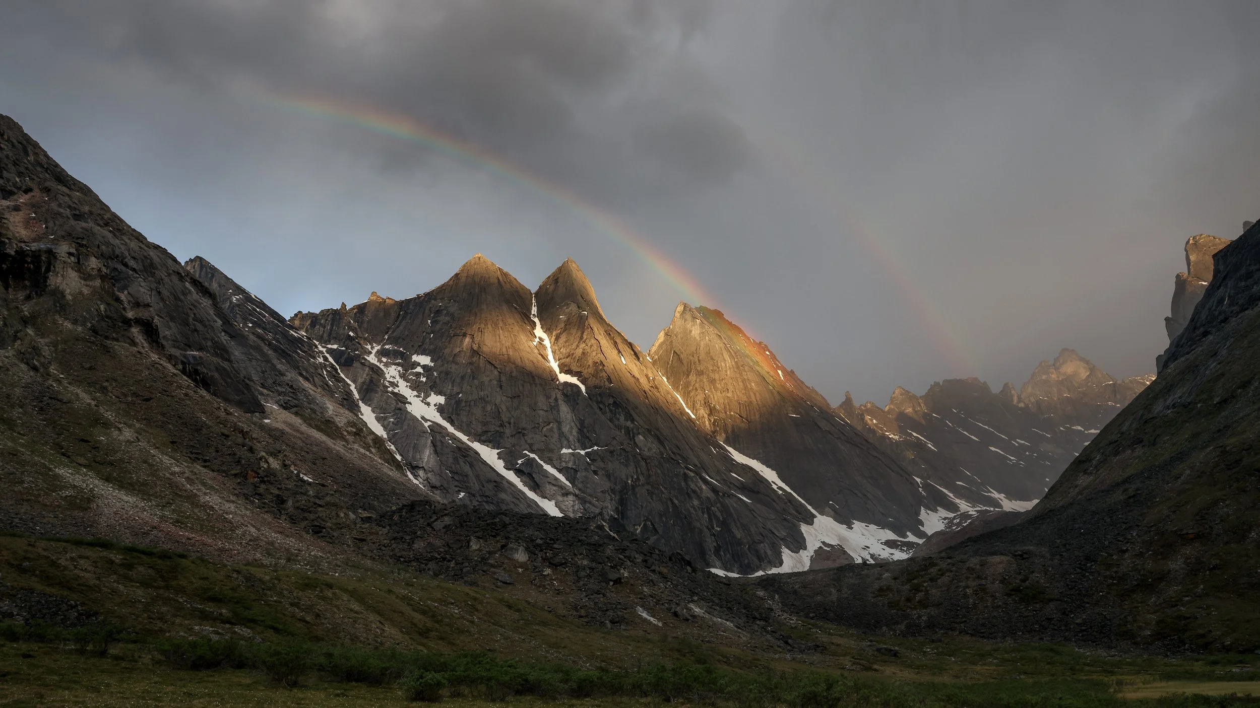
Campsites across the valley are plentiful. We set up camp on a grassy meadow overlooking the towering mountains surrounding the valley. Later that evening, a quick shower yields way to a majestic rainbow which shines across the mountains' faces with a thousand different colors. This was a glorious sight, one of the rare moment where the creator of the world reveals his presence. I can still picture me and my friends sitting in this meadow, admiring the canvas bestowed upon us.
We begin our day by exploring the Aquarius Valley. The ruggedness of these peaks make it a climber’s paradise. Though the peaks culminate at 6,000 ft, this area is very much reminiscent of 10,000+ ft valleys we find in the lower 48. I spotted a pass across the mountains facing the Aquarius valley, leading to a valley south of the Aquarius, where it is rumored there are natural hot springs, perhaps for a different trip. We would return to Circle Lake using the same path we took.
We then made our way back to pool camp, lit a fire and enjoyed a warm meal before heading to our sleeping bags.
We woke up in great spirit, ready to tackle the next part of our adventure. Today’s objective is to return back to the Circle Lake, retrieve our boat, and get to the Alatna River.
We’re wearing our rain gear (hard-shell pants and jackets) as it is raining for the better part of the day. We are hiking down the Arrigetch Creek the same way we came from. As we step on the tundra once again, we stop to glance at the river flowing in the distance. The sky in the Arctic is low, as if the higher latitude means we are closer to space. The clouds formations shift in real time, creating dark peculiar shapes interlaced with the bright colors of the peaking sun. While Northern Alaska is known to be the land of Aurora borealis in the winter, it is also the land of rainbows and during Summer, It is not uncommon to witness three to four rainbows in a single day.
We make our way onto the gruesome tussocks fields back to Circle Lake. This time, it feels exhausting. Throughout this trip I am personally carrying a rifle and the video equipment that was used to create the film displayed in this report.
At last, we join Circle Lake marking the end of our 4-day exploration of the Arrigetch Mountains. Local time is 1am. We inflate our raft, load our gear and start paddling. As mentioned above, there is a drainage connecting Circle Lake to the Alatna. The drainage is located on the far south of the Lake. It is hard to see from a distance therefore we have to navigate close to the bank. Once found, the drainage connects to a network of canals. At this point we simply follow our instinct and navigate the canals that will lead us as close as possible to the river. We are exhausted, we have been on the go for almost 17h and are yearning for sleep. We start cracking jokes while venturing through the narrow canals, surrounded by tall grass. It truly feels like we are somewhere in Vietnam if it was not for the colder temperatures and the fact that a grizzly bear could be coming out of the thick grass at any time. We land on a bank roughly 300ft from the Alatna River. This is our portage. We call upon what little strength we have left and carry our 350lbs load to the river through thick brush and tussocks.
We launch our boat on the Alatna river and later land on a sand bar where we camp for the night. This turned out to be both the most adventurous and grueling day of our trip.
Over the past few days, we would paddle down the Alatna river. The Alatna River has multiple sections, each with varying rapids, mostly class I & II. We initially looked forward to a smooth decent down the river, instead, the size of our boat combined with the conditions we encountered proved otherwise. When fully loaded with gear and paddlers, our boat weighs a total 700 lbs. The heavier the boat, the slower it is along the current.
For three days, the wind turned out to be mostly against us. It would be a higher than anticipated effort to paddle our boat down the Alatna.
I would recommend to use individual packrafts or smaller rafts which are not only lighter and easier to carry on dry land but are also less affected by the wind and easier to maneuver around sweepers and beaver dams.
We paddled all day against wind and rain along the windy river, glancing at the misty mountains in the distance when the weather would allow it.
The wildlife along the river is striking. It doesn’t mind our presence either. The beavers couldn’t be bothered by our passing and would studiously keep on building. It is said that in the arctic, animals tend to be bolder than in the lower 48 and will rarely run away when encountering humans.
Over the next 3 days, we would camp on sand bars along the river. The river is as bountiful as the land. Trouts and chinook salmons fill it during the summer months.
We spent the last night on a sand bar nearby Takahula Lake. From there, we found a path to portage to Takahula Lake. We carried our boat thru the tundra and launched it on the lake. We had previously called our pilot via satellite to inform him of our pick up point. As we sent our final paddle strokes, we glanced at the sky and saw our plane. The pilot toured the lake a few time and landed right behind us, as if it were chasing us. Both our boat and the plane hit the bank at the same time. Our 7-day dream was coming to an end. As the pilot loaded up our gear, he looked at my rifle and said: “45/70?” to which I answered “yes”. These were his only words. Bush pilots don’t talk much, but they know how to make you appreciate the scenery. We flew back to Bettles through low clouds and wind turbulences, hugging the mountain side so close we could see animals.
Gates of the Arctic was the adventure of a lifetime. We are blessed to live in a time where we can still witness the last American frontier.
If you are interested in venturing into Gates of the Arctic, I highly recommend Joe Wilkins’ book: Gates of the Arctic National Park: Twelve Years of Wilderness Exploration. Joe is a seasoned explorer who has spent the better part of a decade venturing into the park.
Joe also appeared on The By Land podcast and provides valuable information on the wilderness area.
Finally, Alaska explorer' Luc Mehl’s website Things to Luc At provide detailed reports on pack rafting expeditions in Gates of the Arctic and across Alaska.