


Direction
While the Ansel Adams Wilderness is located in the Inyo National Forest, the only way to access it via car is vis Red Meadows Road.
Drive to Mammoth Mountains Ski Lodge, located up Minaret Road. It's a busy area with hotels and restaurants. It is where the main ski lift up Mammoth Mountain is located.
Access to Red Meadows Road varies depending on the season:
Spring and Fall
The road is open to traffic. From Mammoth Mountains Ski Lodge, keep driving straight, at which point you will join Minaret Summit Road (in black on the map below), an old narrow road that takes you down the various trailheads and car camping sites in the Ansel Adams Wilderness. The road is very narrow so pay attention.
The road (also called Red Meadows Road) will take you to the various trailheads , including Devils Postpile. Parking is available at each trailhead but limited.
Before getting on Old Minaret Road, a check point run by the Forrest Service will ask you to pay an entrance fee (waived for National Park Pass holder as of 2015).
Summer
Between May and October, Minaret Summit Road is closed to vehicles. In order to access the trailheads, the forest service runs a public shuttle from dawn to dusk to accommodate visitors. If you are visiting during this time (which most people do), you will need to park your car at the main lodge and purchase a round trip bus ticket. The bus stops at all the popular trailhead including Devils Postpile. For more information, visit the Inyo National Forest website.
Winter
During the winter, the road is closed to vehicles and only accessible via snowmobiles or skis.
Introduction
The Ansel Adams Wilderness is a gem of the Sierra Nevada.
It is one of the most breathtaking and inspiring wilderness area I ever visited.
The area is composed of a large network of trails, connecting a multitude of lakes, streams, meadows, forrest and peaks above 14,000 ft.
It is bordered by Yosemite in the west and Mount Whitney in the south, offering countless adventure opportunities.
This area is beautiful no matter which season you choose to visit: It can be backpacked in the Spring / Summer / Fall and skied in the winter. Mount Ritter and Mount Banner (two of the highest rising peaks) offer amazing climbing and mountaineering opportunities and the various passes crossing the western divide allow a passage onto the Yosemite Valley.
This trips reports relates the most popular route. It starts at Agnew Meadow Trailhead, a stunning green meadow. From there, we took a portion of the PCT called the High Trail to Thousand Island Lakes, one of Sierra Nevada’s most famous lake. We then followed an off trail pass to Garnet Lake. On the last day, we hiked back to Agnew Meadows Trailhead.
This trip was led in July 2019, following one of the snowiest winter on record. Lakes were still frozen and several trails over 9,000ft were still under snow.
During heavy snow years when the trails are still buried under snow, proper orienteering skills and maps are required.
Overnight permits are required at all time. They can be obtained online in advance or at any ranger stations. For more information, visit the Inyo National Forest website.
Day 1 - Agnew Meadow to Thousand Island Lake
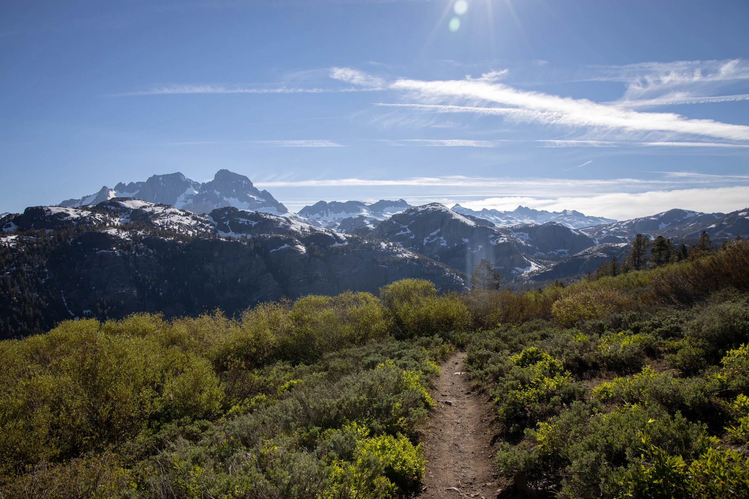
We started out at Agnew Meadows. Our goal for the day was to reach Thousand Island Lake. We opted to use the High Trail (a section of the PCT). The trail gradually climbs one thousand feet to an exposed mountain ridge which provides for an unobstructed vista of the Minarets Range. As we got closer, the vista only got more majestic. Views of Shadow Lake and the surrounding peaks provide for a stunning spectacle. The trail crosses several meadows with wildflowers and water crossings before heading down a valley where we were led to cross the San Joaquin River. Here, the trees abound and provide for some shade from the hard summer sun. From there, the trail goes up a pass which ultimately leads to Thousand Island Lake.
Upon arriving at the lake, we are entering a new world. The Alpine Lake is fed by the glacier of Banner peaks and other surrounding mountains. It is July, yet snow abounds and portions of the Lake are still icy. The ground is a combination of meadows and soft rocks smoothened by the mouvement of glaciers. A few hardened trees still populate this landscape at 9,800ft, a testimony of the vigor of all the beings that call the high sierra home.
We had hiked 8.4 miles. We gained 2,500ft and lost 1,000ft.
We pitched our tent by the lake and prepared dinner. As we filled our stomachs, we were bid farewell by the sun which slipped behind Banner Peak, yielding its harsh daylight for a soft blue hue.
DOWNLOAD TERRAIN PROFILE FOR DAY 1


Day 2 - Thousand Island Lake to Garnet Lake
The goal for the day was to cross a pass south of Thousand Island Lake and join Garnet Lake. The pass (usually well marked by a trail) was entirely covered in snow. We knew this was going to be a fun day of cross country. Before packing up, we dipped our legs into the frozen lake. It is in my opinion the most effective way to relieve achy muscle pain before heading on the trail again.
We strapped our micro spikes and headed for the hill south of Thousand Islands Lakes. We slowly hiked up to the pass and navigated through a network of trees, rocks and smaller alpine lakes. I used my GPS to navigate although a map and compass could be used. We reached the top of the pass which sits 600ft above Thousand Island Lakes and were greeted by the majestic views of one of my personal favorite’s high sierra lakes: Garnet Lake.
We sat down for a snack, then navigated our way down the lake’s bank through a network of small streams. Garnet was covered with a thick sheet of ice and snow. We spotted a little island in the middle of the lake and considered it a good campsite. After testing the rigidity of the ice, we crossed a small section of the lake and safely pitched our tent on a rocky outgrowth overlooking Banner Peak.
We gathered some firewood and started a fire. Usually, fires are not allowed above 10,000 ft in the Sierra, little less in the middle of summer. However, due to the exceptional winter we had experience in 2019, the Forets Service advised that we gather wood for campfire. We were happy to comply.
Garnet Lake is another great lake for trout fishing. It feels wider than Thousand Island Lakes and tend to be more exposed to wind. The tradeoff are the unparalleled and unobstructed views it offers.
We fired up our stove and warmed up around the fire. The light turned red to the east, signaling another dramatic Sierra Sunset.
We hiked a total of 3 mile and climber 600ft. While this does not seem much, navigating cross country in the snow is much more time consuming that walking on a dry trail.
DOWNLOAD TERRAIN PROFILE FOR DAY 2


Day 3 - Garnet Lake back to Agnew Meadows
When camping at Garnet Lake, I advise to wake up before sunrise. Garnet Lake and Banner Peak directly face east and aren’t obstructed. When the sun rises, the glowing light slowly creeps its way from the summit down the top, while providing a clear reflection of the mountain of the lake: A stunning spectacle. While the reflection is not as evident when the lake is covered in snow, it remains quite unique.
We packed our bags and left our little island back to Agnew Meadows. Our intention was to reach the River Trail which follows the San Joaquin River, a roaring river fed by the massive lakes in the area.
We hiked to the eastern flank of the lake then made our way down a steep slope. The slope - usually marked by a trail- was still covered in snow and had to be carefully navigated in order to avoid a fall. It is never fun to go down steep snowy slopes in microspikes but with enough caution, this could be done safely. Finally, we reached a wooded area which signaled we were getting closed to the San Joaquin River. We knew the trail was on the other side of the river, however, after scouting the riverside for almost 1/2h, no crossings were to be found. The river was roaring at full speed, emptying the precipitation of one of California’s wettest winter ever recorded. We later found out that the large log serving as a crossing had been wiped away. We resolved to hiking down the river with the hope that a crossing can be found. Finally, after hiking 2 miles, we found some shallow water. We removed our shoes and pants, and crossed knee-deep. We joined the River Trail and headed back to Agnew Meadows. The River trail is relatively flat and crosses through a heavily wooded area, providing for good shade. As we walked, the river became strong again and later turned into a waterfall.
We finally reached Agnew Meadow and the end of our adventure. During this last eventful day, we hiked close to 7 miles, lost 2,400 feet and gained 1,000 ft.
DOWNLOAD TERRAIN PROFILE FOR DAY 3


Gear
CLOTHING
Base layer
Mid layer
Down Jacket
Softshell jacket (winter only)
Softshell pants (winter only)
Hardshell
Shoes
Gloves
Socks
HARDWARE
Pack
Sleeping bag
Sleeping Pad
Tent (3-season)
Flashlight
Poles
Ice Axe
Microspikes
Crampons (recommended in heavy snow conditions)